Select Menu: Alamosa Colorado || Fort Garland Colorado || San Acacio Colorado || Sangre De Cristo Photos || Colorado Home
Colorado Land Photos || Sample Sales Agreement || Alternative Utilities || Colorado Links
Sangre De Cristo Mountians - San Luis Valley - Mt. Blanca &
The Rio Grande River Areas
SANGRE DE CRISTO MOUNTIANS
The Sangre de Cristo Mountains are one of the longest mountain chains on Earth. They stretch from Poncha Pass, Colorado, in the north to Glorieta Pass, New Mexico, in the south. There are ten peaks over 14,000' high in the range, more than two dozen over 13,000'.
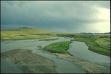
SAN LUIS VALLEY
 San Luis Valley is a large broad alpine valley in the Rio Grande Basin of south-central Colorado. The valley is drained to the south by the Rio Grande which rises in the San Juan Mountains to the west of the valley and flows south into New Mexico. The valley is approximately 122 miles (196 km) long and about 74 miles (119 km) wide extending from the Continental Divide on the northwest to the New Mexico state line on the south. Parts of New Mexico are also considered to be part of the San Luis Valley. San Luis Valley is a large broad alpine valley in the Rio Grande Basin of south-central Colorado. The valley is drained to the south by the Rio Grande which rises in the San Juan Mountains to the west of the valley and flows south into New Mexico. The valley is approximately 122 miles (196 km) long and about 74 miles (119 km) wide extending from the Continental Divide on the northwest to the New Mexico state line on the south. Parts of New Mexico are also considered to be part of the San Luis Valley.
The San Luis Valley is generally considered to comprise 6 counties: Saguache, Alamosa, Rio Grande, Conejos, Costilla and Mineral. The principal towns are: Alamosa, Monte Vista, Del Norte, South Fork, Creede, Saguache, Center, Fort Garland, San Luis, Antonito, La Jara, Manassa, Crestone, Villa Grove, Hooper, Mosca, San Acacio, Colorado and a number of smaller locations, some ghost towns. A few other counties have some land in the Rio Grande Basin including Archuleta County, Colorado, Hinsdale County, Colorado and San Juan County, Colorado
The Sangre de Cristo Mountains form the eastern border of the valley. Blanca Peak is prominent at the southern end of the northernmost section of the mountains, which is known as the Sangre de Cristo Range. There are several passes, with elevations between 9,000 and 10,000 feet (2,700 and 3,000 m), giving access to the valley. La Veta pass, through the Sangre de Cristo Mountains, is used by US Highway 160 and by the Denver and Rio Grande Railroad (D. & R. G.) tracks. Other passes used historically were Medano, Mosca and Sangre de Cristo Passes. Otto Meers was the engineering genius behind the construction of a railroad link from the Arkansas River, over Poncha Pass (at the north end of the valley) and into the San Luis Valley.
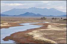 The Great Sand Dunes is a famous feature of the valley. It lies directly to the west of the Sangre de Cristo Mountains, and the sand is said to come from many states surrounding Colorado. Some of the dunes can reach 200 feet high, and the dunes are kept in place by the waters of Medano Creek. The Great Sands Dunes National Monument is now in place to protect both the dunes and the numerous archeological sites found in the area. The natural valley aquifer is close to the surface in this part of the valley, and helps with maintenance of water levels in the San Luis Lakes, just to the west of the sand dunes. The Great Sand Dunes is a famous feature of the valley. It lies directly to the west of the Sangre de Cristo Mountains, and the sand is said to come from many states surrounding Colorado. Some of the dunes can reach 200 feet high, and the dunes are kept in place by the waters of Medano Creek. The Great Sands Dunes National Monument is now in place to protect both the dunes and the numerous archeological sites found in the area. The natural valley aquifer is close to the surface in this part of the valley, and helps with maintenance of water levels in the San Luis Lakes, just to the west of the sand dunes.
Elevation rises as you go north in the valley to Poncha Pass, used now by US Highway 285 and historically by the narrow gauge tracks of the D. & R. G.
About 50% of the 2,000,000 acres (8,000 km˛) in the San Luis Valley is privately owned.
500,000 acres (2,000 km˛) on the borders of the valley, generally abutting National Forest Lands are managed by the Bureau of Land Management, BLM, a division of the United States Department of the Interior. This land is usually leased to neighboring ranches for grazing for a nominal fee. Part of the value of a ranch is its continuing lease of BLM or National Forest lands.
Public lands in the mountains surrounding the San Luis Valley are generally part of the Rio Grande National Forest and are managed by the United States Forest Service.
Agriculture in the San Luis Valley is generally concentrated around the Colorado towns of Alamosa, Monte Vista and Center. Principal crops include potatoes, head lettuce and beer barley. Less favored areas with a shorter growing season and less access to water rights tend to be devoted to alfalfa and grazing.
Sandhill cranes migrate through the valley every Spring and Fall. The Monte Vista Crane Festival takes place in March, and centers on the wildlife refuge located six miles south of town. Occasionally, a whooping crane can be spotted among the thoudsands of grey sandhills. The valley is a flyway for many migrating birds, including avocets, bald eagles, gold finches, and too many types of hawks to list here.
MOUNT BLANCA
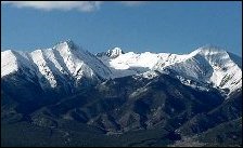 Mt. Blanca has been a sacred place since the first Native Americans arrived in the area thousands of years ago. It is still the setting for many strange tales in the San Luis Valley. The photo above was taken on the side of the West Spanish Peak, southeast of Mt. Blanca. From left to right is Little Bear, Blanca Peak, California Peak, Mt. Lindsey, and Huerfano Peak, all among the 100 highest of Colorado. As beautiful as they are, none of them are walk ups. The primary climbing trail goes up the southwest side of the mountain to Lake Como and beyond on a 4x4 road rated one of the worst in America. That usually takes enough out of you that you'll call it a day when you reach the vicinity of Lake Como. The next day can get you to the top of Blanca and Ellingwood and back down the mountain. Or you can climb Little Bear and maybe do the traverse over to Blanca, but this requires significant technical expertise. Whatever you choose to do, this is a place where Mother Earth is very exposed, very beautiful and very hard-faced. Presided over by the valley's tallest peak (and its namesake), the small community of Blanca serves as one of two unofficial gateways to the Great Sand Dunes National Park and Preserve. Two general stores, an art gallery and two locally-owned restaurants offer visitors a quick dining option after a great day out at the dunes. Mt. Blanca has been a sacred place since the first Native Americans arrived in the area thousands of years ago. It is still the setting for many strange tales in the San Luis Valley. The photo above was taken on the side of the West Spanish Peak, southeast of Mt. Blanca. From left to right is Little Bear, Blanca Peak, California Peak, Mt. Lindsey, and Huerfano Peak, all among the 100 highest of Colorado. As beautiful as they are, none of them are walk ups. The primary climbing trail goes up the southwest side of the mountain to Lake Como and beyond on a 4x4 road rated one of the worst in America. That usually takes enough out of you that you'll call it a day when you reach the vicinity of Lake Como. The next day can get you to the top of Blanca and Ellingwood and back down the mountain. Or you can climb Little Bear and maybe do the traverse over to Blanca, but this requires significant technical expertise. Whatever you choose to do, this is a place where Mother Earth is very exposed, very beautiful and very hard-faced. Presided over by the valley's tallest peak (and its namesake), the small community of Blanca serves as one of two unofficial gateways to the Great Sand Dunes National Park and Preserve. Two general stores, an art gallery and two locally-owned restaurants offer visitors a quick dining option after a great day out at the dunes.
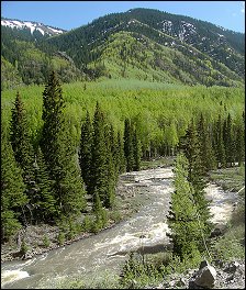
RIO GRANDE RIVER
 The Rio Grande flows from its headwaters in the San Juan Mountains of southern Colorado for 1,865 miles to the Gulf of Mexico near Brownsville, Texas. For 1,250 miles, the Rio Grande is the boundary between the United States and Mexico. Spectacular and developing quickly, the San Luis Valley of Southern Colorado is among the largest montane valleys in the world, and impressive by any standard. It is in part renowned as the location where the first waters of the Rio Grande descend from the Colorado Rockies, arriving initially in Colorado, but quickly moving into Northern New Mexico.
FORT GARLAND
Historic Fort Garland sits on the edge of the Sangre de Cristo Mountains, an unofficial "welcome" center for visitors traveling from the east into the valley on Highway 160. Once the setting of an official military outpost commanded by the famed Kit Carson, the town still boasts a commissary and military museum, complete with historic re-enactments. Rustic dining, lodging and shopping are available along the main thoroughfare.
ANTONITO
Home of Colorado's oldest church and a colorful community rich in multi-generational hispanic farming and ranching families, Antonito is the San Luis Valley's southern outpost before crossing the border into New Mexico just a few miles down the road. Here, the valley's own Rio Grande Scenic Railroad connects each weekend with the Cumbres & Toltec Scenic Railroad - one of the only spots left on earth where standard and narrow gauge track meet.
SAN LUIS
Colorado's oldest town is a special "must-stop" for any valley vacationer looking for a fascinating secret (or gallery, or piece of homemade pie..) In its beautiful setting at the foot of the Sangre de Cristo Mountains, most visitors go to walk the trail of the Stations of the Cross Shrine with its bronze sculptures depicting the last days of Christ’s life. Look closely for the many, many murals on the historic walls of vibrant, charming San Luis.
CLICK HERE FOR HUNTING, FISHING, GUIDE AND OUTFITTER LINKS!
 Click here For info on ALTERNATIVE RESOURCES FOR RURAL HOMES Click here For info on ALTERNATIVE RESOURCES FOR RURAL HOMES
BillyLand
HC71, Box 495c
Hanover, NM 88041
Toll free (800) 724-0551
Billy@BillyLand.com
|